Posts

Showing posts with the label GPS

Off-the-fieldnotes: On fieldworks using Handheld receivers

Image
Last week was one tedious week, part of my primary data gathering is to map all the storm drains within my study area for my thesis. That was about 371 hectare area of land with a mix of residential, commercial and industrial land uses. I have used 2 types of Garmin Handheld receivers for this part, the Garmin Oregon 550 and the Garmin 76CSx for this storm drain inventory and mapping field work. I would say that both are pretty good in terms of accuracy for a handheld receivers with a purpose of mapping  features just for reconnaissance or coarse accuracy requirements. Here are my rants/raves two cents for fieldworks utilizing handheld GPS receivers i.e. GARMIN GPSmap 76CSx and Oregon 550. Do understand the primary purpose or objective of your data gathering and use the right tool for such purpose. -  You can't use a handheld GPS receiver to plot the corners of your lot and use it as an evidence for a land grabbing case. Have a clear understanding of the capabilities of t...

Back-sighting the history of Surveying

Image
Last November 28- December 2, 2011, I had the chance to participate in a course for GPS data analysis and modelling (GDAM) for scientific and practical application workshop held at the National Engineering Center of UP Diliman. Part of the itinerary is a day of field trip to the major research agencies that uses Global Positioning Systems (GPS) in the modelling and analysis of crustal movements for their respective scientific applications. The agencies that we have visited are the Philippine Institute of Volcanology and Seismology (PHIVOLCS),  Manila Observatory and the National Mapping and Resource Information Authority (NAMRIA). At PHIVOLCS we get a peek on how the GPS data from continuous and campaign sites have been archived, processed and delivered. These data will then be used further for the analysis of crustal movements specifically along the Philippune Fault as well as the deformation and movements on active volcanoes in the Philippines such as Mayon and Kanlaon. H...

What's keeping me so busy right now?

Image
Lately I haven't had much time updating all my blogs because I'm currently dealing with some LIDAR data for my graduate thesis. I am quite bittered of the fact that really, this is more of a programming than analysis thing. I am more burdened of learning a new programming language or more so 'languages' just to be able to get meaningful results out of my raw data. I have been inspired by another blog to just chronicle all my findings and queries so I can help others and so others may be able to help me too. Also I guess this would be a good documentation for my future write ups for my methodologies. So to start with. I am using a HDL-32E Velodyne LIDAR. It's a laser rangefinder that uses 32 lasers cupped inside a TIN-CAN-SIZED enclosure that's set to generate approximately 700,000 points per second. I have actually found quite a number of resources even codes about Velodyne LIDAR but it's on the HDL-64E and so porting the codes to the 32E is quite dang...

Applying inSAR principles to detect surface deformation in Metro Manila

Image
I have just attended an InSAR training  showing how to detect surface deformation through phase differences between SAR signals. SAR satellite transmits microwave to earth and receives reflected microwave signals from earth surface. The intensity of received microwave indicates electromagnetic characteristics of objects, and phase indicates distance between aperture and object. Surface deformation is measured by the difference in two observed phases. The observed phase differences still contains errors that ought to be corrected along processing enumerated by the steps below. Getting SLC (Single-Look Complex) Co-registration (registration of Master and Slave images) Interferometry ( measuring phase differences) Corrections (Removal of Orbital and Topographic Fringe) Phase Unwrapping (integration of extracted to actual phase difference) Geocoding Visualization of Results in ENVI Analysis and Interpretation With the use of ALOS Palsar images from two different instances ...

Instant information experience for GPS using Qwiki

A " Qwiki " is a short, interactive story: a drastically improved information experience provided via interactive video. This is a great tool for research. It has an interactive interface highly visual in nature with short notes that is really comprehensive and smart. I have tried querying on GPS and this is the result: View Global Positioning System and over 3,000,000 other topics on Qwiki . Qwiki is really super nice with the instant upload on my favorite social networking sites. You must try it too!

Android apps for the fitness buff or for just about anyone who wants to loose some pounds after the holiday eating splurge

Image
The Christmas holiday is over. The dilemma on late Christmas shopping, what-gifts-to-buy, and party hopping is finally over. And now for the first quarter of the year, fitness centers are on a boom! I sure bet that many swore again to loose the extra pounds they've acquired due to excessive partying, reunions and not to mention the abundant Noche Buena (Christmas eve dinner) and Media Noche (New Year's eve meal). Diet and exercise is again on top of the list of our ever famous New Year's Resolution. Well, since we've recently acquired a cool phone that allows us to download lots of free stuff over the net, I'd better start trying out this cool fitness android apps. Here are some of them (in no particular order since I haven't tried anyone of these just yet...) For exercise, weight training and just about any fitness routine: 1.   JEFIT   - Workout Planner with hundreds of workout exercise. Smart workout logs. Sync your progress with PC. Charts...

University of the Philippines Diliman Campus

Image
In our GIS class for Geomatics Engineering, we were asked to digitize a pan-sharpened Quickbird image of UP Diliman and specify the roads, buildings, and open spaces in the campus. Also this is my first time to import data from a handheld GPS into my GIS. Here's my output map: We we're also asked to georeference a "very old" aerial photo of UP Diliman campus. Here's the result:

Creating GIS data: Importing from text files and other sources

Image
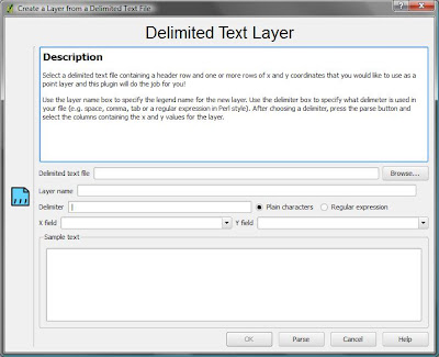
Oftentimes we have some data begging to be included in our GIS but the file format just couldn't fit in. For example we have found the data over the internet and it is not in .dbf  or .gdb format. But as long as it has a coordinate system data (i.e. latitude, longitude) there is still a way to include that in our GIS project. My latest GIS project is on including a delimited text layer in QGIS. QGIS supports the import of points only , while GRASS can accommodate all feature types in the GRASS vector model. My GIS Project What I have done is to map the location of all GPS campaign stations that our team has established since 1995. I have extracted the geographic location (latitude and longitude) information from the final coordinates file (FN*.crd) produced by Bernese 5.0 after post-processing the GPS data we have gathered on field. I have actually converted it from FILE format to .txt then imported the data in my GIS project. The Steps Firstly, I looked for a shapefile that covers...

Generating a single HTML file to download International GNSS Service (IGS) Stations via ftp

The GPS Project I am part of the GPS-Active Fault Deformation Mapping project in the Philippines. Through GPS we are trying to study the kinematics of the Philippine Fault, the result of which aims to develop  a more comprehensive program on the evaluation of seismic hazards and risks as an essential component of earthquake disaster mitigation projects.   Our team uses Bernese 5.0 for GPS post-processing. Bernese enables us to utilize nine (9) International GNSS Service (IGS) stations near the Philippines. Addition of these 9 IGS stations to our local campaign or continuous sites increase the accuracy and stability of our network.  The IGS stations that we have included are the following:  Mon. Name    Site Name      Lat        Long     Receiver BAKO            Cibinong        -06 29   106 ...

WORDLE: create artworks from a word cloud

Image
Wordle is a toy for generating “word clouds” from text that you provide. The clouds give greater prominence to words that appear more frequently in the source text. You can tweak your clouds with different fonts, layouts, and color schemes. The images you create with Wordle are yours to use however you like. You can print them out, or save them to the Wordle gallery to share with your friends.  I tried to input my resume and here's how it looked like:  I tried experimenting on some designs and got this:  It's also a good check if your resume are in good shape or are you sending the impression that you want your employer to catch based on your resume. I just realized herein that I have been so much into GPS than my first love... GIS. So I have to do some minor revisions then. Try Wordle too by clicking this link : http://www.wordle.net/create

Free Philippine Administrative Boundaries shapefile

Image
Free Administrative Boundary shapefile can be downloaded here . The coordinate reference system is latitude/longitude and the WGS84 datum. Other file formats such as ESRI geodatabase (.gdb), Google Earth (.kmz), and RData for RProject. Geospatial data from other countries are also available for download here. File Formats A "shapefile" consist of at least three actual files. This is a commonly used format that can be directly used in Arc-anything, DIVA-GIS , and many other programs. Unfortunately, non-latin characters are garbled. An "ESRI geodatabase" is an MS Access fole that can be opened in ArcGIS (an expensive but powerful program). One of its advantages, compared to a shapefile, is that it can store non-latin characters (e.g. Cyrillic and Chinese characters). A "Google Earth .kmz" file can be opened in Google Earth . A "RData" file can be used in R (with the sp package loaded) Some files have been compressed and grouped i...

EXTRACTING COMPACT RINEX FORMAT

Image
Most IGS* stations archive data in compact rinex format. I have had a hard time figuring out how to decompress this files. Just follow the following steps: 1. Download RNXCMP_4.0.4_Windows.tar through this link : 2. Extract the bin folder contains the following files: 2. Save the following scripts as Windows batch file (example: 00D_00o.bat) to the same folder where you have saved the compact rinex files and the extracted bin files from RNX 4.0.4 Windows tar file above. ********************************************************************************** @echo off REM  decompressing the *.99e to *.99o automatically: REM REM  decompressing     *.99e to *.99d REM  restore           *.99d to *.99o REM      del  crz2x.tmp      del  crz2x.bat      for %%f in (*.9?d) do ECHO call crz2rnx1 %%f >> crz2x.tmp      for %%f...