Posts

Showing posts with the label MY PROJECTS

We've got an android ínside our ride this morning

Image
Lately we've been minding some few renovations inside our ride. When we have just purchased a new sound system inside it, we thought of actually having something to view upon. A mobile theater system so to speak. We usually place our notebook in the dashboard then let our kids watch from the backseat, but too bad, it doesn't have some solid state drive so we're afraid it might get damaged because of some vibrations. Then we just decided to buy an APad , a smaller one and something that would fit rightly on top of our dashboard. We grabbed a unit of an aPad ( MID APad M701  7.0 Inch Touch Screen  Android Tablet PC ) because its cheap and its running in Android OS. Android is opensource and there's an android app market installed in it where we can shop for cools apps for free. And for it's purpose as an in-house movie player for our car, it would serve very much beyond our need. I can do my e-book reading (as a colored version of a Kindle ), plants vs zombi...

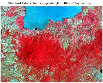
Image Registration and Georeferencing in ENVI (Cavite, Philippines)

Image
Georeferencing and Registration Methodology T he following steps were undertaken for the rectification or georeferencing of the image: 1. I have created a subset of the province of Cavite from the Landsat ETM+image that I have downloaded from GLCF . A topographic map of the equivalent subset has been obtained with the following basemap information. Fig. 1: Basemap information Scale 1: 50000.. Sheet name Cavite, Philippines Sheet number 3163 II Source NAMRIA 2.  A scanned 1:50000 topographic map of Cavite appears below. Fig. 2a: 1:50000 Topographic map of Cavite 3.  An Image-to-map registration was performed using the coordinates on the boundary of the map as ground control points. A total of 10 points are obtained with a total RMSE of 0.396853. 4.  An Image-to-Image registration was later performed, yielding 9 GCPs with a total RMS error of 0.970929. The Landsat ETM+ image that I have obtai...

Principal Components Analysis

Image
 Principal Component Analysis (PCA) aims to eliminate the interband correlation and the effective dimensionality of the data or image. The false color composite of the original Laguna.img file appears below. Fig. 1: Standard color infrared composite image   The satellite image from Google Earth of Los Banos, Laguna was also included for identification of features and their names. Fig. 1a shows the saved image. Fig.1a: Google Earth image of Los Banos, Laguna   After subjecting the original image to principal components analysis, a color composite using PC1,PC2,PC3 as R,G,B respectively was produced. The color composite image was shown in the figure that follows. Fig. 2: RGB = PC1,PC2,PC3 of Laguna.img The six principal component grayscale images appear below. Fig. 3: Output principal component images  The tonal patterns of the principal component image 1 differ with that of ETM+ band 1 of Laguna.img. Figure 4 shows the a generlized view of the sa...