Posts

Showing posts with the label Open Source tools

We've got an android ínside our ride this morning

Image
Lately we've been minding some few renovations inside our ride. When we have just purchased a new sound system inside it, we thought of actually having something to view upon. A mobile theater system so to speak. We usually place our notebook in the dashboard then let our kids watch from the backseat, but too bad, it doesn't have some solid state drive so we're afraid it might get damaged because of some vibrations. Then we just decided to buy an APad , a smaller one and something that would fit rightly on top of our dashboard. We grabbed a unit of an aPad ( MID APad M701  7.0 Inch Touch Screen  Android Tablet PC ) because its cheap and its running in Android OS. Android is opensource and there's an android app market installed in it where we can shop for cools apps for free. And for it's purpose as an in-house movie player for our car, it would serve very much beyond our need. I can do my e-book reading (as a colored version of a Kindle ), plants vs zombi...
Creating Entity-relationship Diagrams (E-R Diagrams)

Image
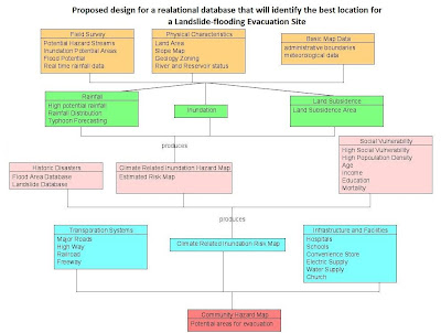
Last semester for my introductory GIS class, part of a laboratory exercise is on creating E-R Diagrams which for me is a simple graph of the relationships between different objects within an interface. In programming, it is much like the UML (Unified Modeling Language) class diagrams that we are making before proceeding to the actual coding. E-R diagram  A data model, which is a high level description of the available data, is needed in storing relevant information in a database. In designing databases, there should be a conceptual and the physical phase. The creation of E-R (entity-relationship) diagrams belong to the conceptual phase. The E-R diagram serves as the blueprint before creating a database. There are things such as entity sets within an E-R Diagram 1. Entity – person, place, object, event, concept.  representation in the E-R diagram - table in the database shape in the E-R diagram -  RECTANGLE  2. Entity sets – collection of similar entities (sa...

Free PDF to WORD options

Image
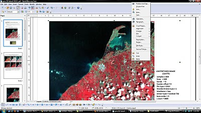
Latest versions of Microsoft Office and OpenOffice are already capable of  saving your  documents from doc, docx or odt to  pdf format. The reverse is quite unusual. There are trial versions of pdf to word converter with their limitations of course. PDF2Word  can only be used 100 times and allows the first 5 pages only to be converted to .doc format. Fonts change and the layout was a bit different after conversion.  The most useful for me is using the OpenOffice PDF Import Extension . If you have OpenOffice  installed in your pc, just double click the downloaded extension and an installation dialog will guide you through.  The pdf opens in OpenOfficeDraw and lets you do basic editing of text and images in the document. You can save the edited file as another pdf or export as an image file or in html format.  It's free and it's open source so let's see more developments of this extension on OpenOffice. It would be nicer if pdf files can be ope...

Tool for Backing Up Your Blog or Downloading an Entire Website for Offline Browsing

I have just learned that a friend's blog site was hacked and was totally deleted. The incident alarmed me so much that the same thing could possibly happen to my blog hence I tried to look for possible means of backing it up. An easy way to get all the posts in an XML feed. This is a better format if you intend to import it in a database. http://blogname.blogspot.com/feeds/posts/default?max-results=1000 You can also backup the comments: http://blogname.blogspot.com/feeds/comments/default?max-results=1000 Another option is to send your blogs to your e-mail for back-up. Ultimately you may opt to use a third party software that downloads an entire site and have it saved in your local disk. HTTrac k is a free ( GPL , libre/free software) and easy-to-use offline browser utility. It allows you to download a World Wide Web site from the Internet to a local directory, building recursively all directories, getting HTML, images, and other files from the server to your computer. HTTrac...

Creating GIS data: Importing from text files and other sources

Image
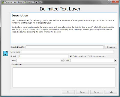
Oftentimes we have some data begging to be included in our GIS but the file format just couldn't fit in. For example we have found the data over the internet and it is not in .dbf  or .gdb format. But as long as it has a coordinate system data (i.e. latitude, longitude) there is still a way to include that in our GIS project. My latest GIS project is on including a delimited text layer in QGIS. QGIS supports the import of points only , while GRASS can accommodate all feature types in the GRASS vector model. My GIS Project What I have done is to map the location of all GPS campaign stations that our team has established since 1995. I have extracted the geographic location (latitude and longitude) information from the final coordinates file (FN*.crd) produced by Bernese 5.0 after post-processing the GPS data we have gathered on field. I have actually converted it from FILE format to .txt then imported the data in my GIS project. The Steps Firstly, I looked for a shapefile that covers...

DESKTOP GIS: MAPPING THE PLANET WITH OPEN SOURCE TOOLS

PART 1 NOTES: common formats •Shapefiles(.shp) •GeoTIFForTIFFwithworldfiles(.tif,.tfw) •JPEGwithworldfiles(.jpg,.jpw) •GPSdata(.gpx) other vector formats •ArcInfoBinaryCoverage •ArcInfoInterchangeFile(.e00 •MapInfo(..tab,.mid,.mif) •SDTS,adatatransferstandardforbothvectorandrasterdata1 •TopologicallyIntegratedGeographicEncodingandReferencing (TIGER)data,usedanddistributedbytheU.S.CensusBureau •DigitalLineGraphics(DLG) other raster formats •ERMapperCompressedWavelets(.ecw) •ErdasImagine(.img) •DigitalElevationModels(.dem) •JPEG2000(.jp2,.j2k) •Multi-ResolutionSeamlessImageDatabase(MrSID)(.sid) •GTOPO30,aglobaldigitalelevationmodel(DEM)derivedfroma numberofrasterandvectorsources Note: use an OSGIS software that uses GDAL/OGR for accessing raster and vector data (GRASS and QGIS) data format deliverable over the web: Open Geospatial Consortium website http://www.opengeospatial.org WebMappingService(WMS), PostGIS -Creating a POSTGis-enabled database: WebFeaturesService(WFS), WebCoverageService...