Posts

Showing posts with the label free GIS softwares

Android apps for the fitness buff or for just about anyone who wants to loose some pounds after the holiday eating splurge

Image
The Christmas holiday is over. The dilemma on late Christmas shopping, what-gifts-to-buy, and party hopping is finally over. And now for the first quarter of the year, fitness centers are on a boom! I sure bet that many swore again to loose the extra pounds they've acquired due to excessive partying, reunions and not to mention the abundant Noche Buena (Christmas eve dinner) and Media Noche (New Year's eve meal). Diet and exercise is again on top of the list of our ever famous New Year's Resolution. Well, since we've recently acquired a cool phone that allows us to download lots of free stuff over the net, I'd better start trying out this cool fitness android apps. Here are some of them (in no particular order since I haven't tried anyone of these just yet...) For exercise, weight training and just about any fitness routine: 1.   JEFIT   - Workout Planner with hundreds of workout exercise. Smart workout logs. Sync your progress with PC. Charts...
Creating Entity-relationship Diagrams (E-R Diagrams)

Image
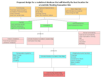
Last semester for my introductory GIS class, part of a laboratory exercise is on creating E-R Diagrams which for me is a simple graph of the relationships between different objects within an interface. In programming, it is much like the UML (Unified Modeling Language) class diagrams that we are making before proceeding to the actual coding. E-R diagram  A data model, which is a high level description of the available data, is needed in storing relevant information in a database. In designing databases, there should be a conceptual and the physical phase. The creation of E-R (entity-relationship) diagrams belong to the conceptual phase. The E-R diagram serves as the blueprint before creating a database. There are things such as entity sets within an E-R Diagram 1. Entity – person, place, object, event, concept.  representation in the E-R diagram - table in the database shape in the E-R diagram -  RECTANGLE  2. Entity sets – collection of similar entities (sa...

merge tabfiles and shapefiles in one single shapefile

GeoMerge is a free geoprocessing tool which combines  ESRI shapefiles into one shapefile and even merges shapefiles and MapInfo tabfiles and ESRI shapefile into a single shapefile. Files with the same column definitions in the .dbf files will be concatenated in the new shapefile. Download GeoMerge.exe and see full details though this link.