Posts

Showing posts with the label remote sensing

Applying inSAR principles to detect surface deformation in Metro Manila

Image
I have just attended an InSAR training  showing how to detect surface deformation through phase differences between SAR signals. SAR satellite transmits microwave to earth and receives reflected microwave signals from earth surface. The intensity of received microwave indicates electromagnetic characteristics of objects, and phase indicates distance between aperture and object. Surface deformation is measured by the difference in two observed phases. The observed phase differences still contains errors that ought to be corrected along processing enumerated by the steps below. Getting SLC (Single-Look Complex) Co-registration (registration of Master and Slave images) Interferometry ( measuring phase differences) Corrections (Removal of Orbital and Topographic Fringe) Phase Unwrapping (integration of extracted to actual phase difference) Geocoding Visualization of Results in ENVI Analysis and Interpretation With the use of ALOS Palsar images from two different instances ...

I have just finished the RADAR training by JAXA-Sentinel Asia

Image
 Being part of the GPS Team in our office, we are tasked to map the crustal deformation along the Philippine Fault as well as other tectonically active locations in the Philippines using Differential GPS. Apart from GPS , there are other means of quantifying such deformation, one is through remote sensing with the use of satellite images. RADAR is a means to remotely sense and analyse an environment such as the Earth. I have just been part of a RADAR training, specifically inSAR (Interferometric Synthetic Aperture Radar) that was held in the Philippine Institute of Volcanology and Seismology (PHIVOLCS) Auditorium held last September 5-6. This technical training was brought to us by JAXA - Sentinel Asia. It was an engaging experience and I surely learned a lot. Will have a separate post for that later. I am looking forward to applying the principles in the current research projects that I am in.

Image Registration and Georeferencing in ENVI (Cavite, Philippines)

Image
Georeferencing and Registration Methodology T he following steps were undertaken for the rectification or georeferencing of the image: 1. I have created a subset of the province of Cavite from the Landsat ETM+image that I have downloaded from GLCF . A topographic map of the equivalent subset has been obtained with the following basemap information. Fig. 1: Basemap information Scale 1: 50000.. Sheet name Cavite, Philippines Sheet number 3163 II Source NAMRIA 2.  A scanned 1:50000 topographic map of Cavite appears below. Fig. 2a: 1:50000 Topographic map of Cavite 3.  An Image-to-map registration was performed using the coordinates on the boundary of the map as ground control points. A total of 10 points are obtained with a total RMSE of 0.396853. 4.  An Image-to-Image registration was later performed, yielding 9 GCPs with a total RMS error of 0.970929. The Landsat ETM+ image that I have obtai...

Principal Components Analysis

Image
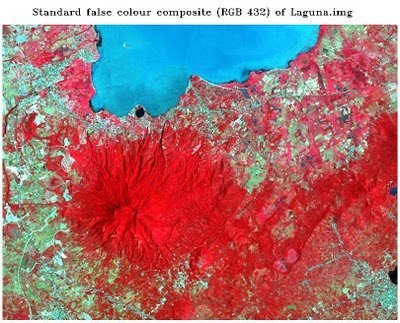
 Principal Component Analysis (PCA) aims to eliminate the interband correlation and the effective dimensionality of the data or image. The false color composite of the original Laguna.img file appears below. Fig. 1: Standard color infrared composite image   The satellite image from Google Earth of Los Banos, Laguna was also included for identification of features and their names. Fig. 1a shows the saved image. Fig.1a: Google Earth image of Los Banos, Laguna   After subjecting the original image to principal components analysis, a color composite using PC1,PC2,PC3 as R,G,B respectively was produced. The color composite image was shown in the figure that follows. Fig. 2: RGB = PC1,PC2,PC3 of Laguna.img The six principal component grayscale images appear below. Fig. 3: Output principal component images  The tonal patterns of the principal component image 1 differ with that of ETM+ band 1 of Laguna.img. Figure 4 shows the a generlized view of the sa...