Posts

Showing posts from March, 2010

Tool for Backing Up Your Blog or Downloading an Entire Website for Offline Browsing

I have just learned that a friend's blog site was hacked and was totally deleted. The incident alarmed me so much that the same thing could possibly happen to my blog hence I tried to look for possible means of backing it up. An easy way to get all the posts in an XML feed. This is a better format if you intend to import it in a database. http://blogname.blogspot.com/feeds/posts/default?max-results=1000 You can also backup the comments: http://blogname.blogspot.com/feeds/comments/default?max-results=1000 Another option is to send your blogs to your e-mail for back-up. Ultimately you may opt to use a third party software that downloads an entire site and have it saved in your local disk. HTTrac k is a free ( GPL , libre/free software) and easy-to-use offline browser utility. It allows you to download a World Wide Web site from the Internet to a local directory, building recursively all directories, getting HTML, images, and other files from the server to your computer. HTTrac

Run MacOS7, OpenOffice, VLC, Foxit Reader, GIMP, etc. directly from a USB drive

Image
Now you can carry your favorite computer programs along with all of your bookmarks, settings, email and more with you. Use them on any Windows computer. All without leaving any personal data behind. Portableapps.com provides a rich array of programs that you want included in your suite. Apart from your usual Windows Start Menu, PortableApps suite produces another sort-of start menu in your pc, that of which containing your selected portable applications. I do not keep a printer at home, so as always, I would have to save all my stuffs on my USB drive and have the files printed at the nearest Internet Cafe. Oftentimes it annoys me that such "Internet" shops don't even have a pdf reader installed in their pc or at times didn't bother to consider installing openOffice Suite hence my .odt and .ods files can't be editted at all. But those are just simple but really very disappointing and oftentimes hopeless cases I have encountered before I discovered

Everything Search Engine- Lightweight Program that do search so fast.

Image
For a work that's highly engaged in really terrible file-handling, memorizing filenames and their paths is really an oblivious task. " Everything " is the ultimate desktop search engine for me. Just pressing the hotkeys, which can be user-specified ofcourse, (it's CTRL+ALT+F for me), typing in just a few letters of the hinted file or folder name and voila the file I've been searching for  is already at my fingertips! " Everything " is an administrative tool that locates files and folders by filename instantly for Windows. Unlike Windows search "Everything" initially displays every file and folder on your computer (hence the name "Everything"). You type in a search filter to limit what files and folders are displayed. What I like about Everything: Boolean operators,regex and widcards can be used. It loads lightning fast! Can be assigned with a shortcut key It monitors file system changes. It opens in multiple windows. It'

Deleting a file that can't be deleted, Removing a USB drive that can't be safely removed

Image
I find this freeware very useful in safely removing flash disks and in deleting the cannot be deleted files! Unlocker is the ultimate unlocker assistant for me. Oftentimes it annoys me when an error message such as this appears on my screen. It's either another program is trying to index the content of my drive or there has been a sharing violation. The clear thing is I cannot do what I'm suppose to do next. Good thing there is this Unlocker Assistant for me. It gives you the option to choose a specific program that will "Unlock" the file or "Unlock All" if you want to stop all programs from accessing your file or drive. Just right-click on the file or drive that you want to delete or remove respectively and choose from a menu for your next actions.  I'm just glad someone out there took time to figure out how to solve this problem and spare me the headache on worrying much bigger problems than just safely removing my drive. Click this lin

merge tabfiles and shapefiles in one single shapefile

GeoMerge is a free geoprocessing tool which combines  ESRI shapefiles into one shapefile and even merges shapefiles and MapInfo tabfiles and ESRI shapefile into a single shapefile. Files with the same column definitions in the .dbf files will be concatenated in the new shapefile. Download GeoMerge.exe and see full details though this link.

Add Google Reader Shared Feed's Widget to Blogger

Image
I have long been figuring out on how can I integrate my Google Reader shared feeds to my blogs. Fortunately I came accross this link: http://www.google.com/reader/clip-creator/user/-/state/com.google/broadcast Just adjust some settings and  click on the icon similar to the icon below for seamless Reader-Blogger integration. You just have to be logged in to your Blogger and Google account to enable embedding.

Creating GIS data: Importing from text files and other sources

Image
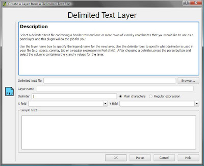
Oftentimes we have some data begging to be included in our GIS but the file format just couldn't fit in. For example we have found the data over the internet and it is not in .dbf  or .gdb format. But as long as it has a coordinate system data (i.e. latitude, longitude) there is still a way to include that in our GIS project. My latest GIS project is on including a delimited text layer in QGIS. QGIS supports the import of points only , while GRASS can accommodate all feature types in the GRASS vector model. My GIS Project What I have done is to map the location of all GPS campaign stations that our team has established since 1995. I have extracted the geographic location (latitude and longitude) information from the final coordinates file (FN*.crd) produced by Bernese 5.0 after post-processing the GPS data we have gathered on field. I have actually converted it from FILE format to .txt then imported the data in my GIS project. The Steps Firstly, I looked for a shapefile that covers

Generating a single HTML file to download International GNSS Service (IGS) Stations via ftp

The GPS Project I am part of the GPS-Active Fault Deformation Mapping project in the Philippines. Through GPS we are trying to study the kinematics of the Philippine Fault, the result of which aims to develop  a more comprehensive program on the evaluation of seismic hazards and risks as an essential component of earthquake disaster mitigation projects.   Our team uses Bernese 5.0 for GPS post-processing. Bernese enables us to utilize nine (9) International GNSS Service (IGS) stations near the Philippines. Addition of these 9 IGS stations to our local campaign or continuous sites increase the accuracy and stability of our network.  The IGS stations that we have included are the following:  Mon. Name    Site Name      Lat        Long     Receiver BAKO            Cibinong        -06 29   106 51   LEICA GRX1200GG DAEJ             Taejon           36 24    127 22   Trimble NETRS GUAM            Guam            13 26    144 48   Trimble NETR5 PIMO             Quezon City   14 38    121

WORDLE: create artworks from a word cloud

Image
Wordle is a toy for generating “word clouds” from text that you provide. The clouds give greater prominence to words that appear more frequently in the source text. You can tweak your clouds with different fonts, layouts, and color schemes. The images you create with Wordle are yours to use however you like. You can print them out, or save them to the Wordle gallery to share with your friends.  I tried to input my resume and here's how it looked like:  I tried experimenting on some designs and got this:  It's also a good check if your resume are in good shape or are you sending the impression that you want your employer to catch based on your resume. I just realized herein that I have been so much into GPS than my first love... GIS. So I have to do some minor revisions then. Try Wordle too by clicking this link : http://www.wordle.net/create

GeoGREETINGS: How Geeks show they care.

Image
Out of the very busy day, I still have time to send my husband sweet regards. Just discovered the site and really had fun! What the program does is to let you enter a random phrase and the program automatically designates a structure found in the world map that would resemble the letters that you have typed. More interestingly, it has ♥ and smileys in it which makes it really cool. Here's my geoGreeting card and is animated through this link . Try showing how much you care too by clicking this link: http://www.geogreeting.com/main.html

Free Philippine Administrative Boundaries shapefile

Image
Free Administrative Boundary shapefile can be downloaded here . The coordinate reference system is latitude/longitude and the WGS84 datum. Other file formats such as ESRI geodatabase (.gdb), Google Earth (.kmz), and RData for RProject. Geospatial data from other countries are also available for download here. File Formats A "shapefile" consist of at least three actual files. This is a commonly used format that can be directly used in Arc-anything, DIVA-GIS , and many other programs. Unfortunately, non-latin characters are garbled. An "ESRI geodatabase" is an MS Access fole that can be opened in ArcGIS (an expensive but powerful program). One of its advantages, compared to a shapefile, is that it can store non-latin characters (e.g. Cyrillic and Chinese characters). A "Google Earth .kmz" file can be opened in Google Earth . A "RData" file can be used in R (with the sp package loaded) Some files have been compressed and grouped i

How to Transfer Certificate of Title after buying a property in Metro Manila,Philippines

How to Transfer Certificate of Title after buying a property in Metro Manila,Philippines : " If someone wants to buy a lot, his first notion was to get a real estate broker to do all the processing. But if the buyer has ample time, with just a few knowledge and some resourcefulness, he can surely do all the processing without having to throw-off some extra bucks for service charges. Here are the few easy steps to transferring your newly acquired lot under your name: Summary of requirements 1. Preparation of the deed of sale and ratification by notary public. 2. Obtain a certified true copy of latest tax declaration from the Assessor’s Office of the city where the lot is located. 3.Payment of Documentary Stamp Tax and Capital Gains Tax at an authorized bank. 4. Obtain tax clearance (or Certificate Authorizing Registration(CAR)) from the Bureau of Internal Revenue 5. Obtain a tax clearance certificate of Real Estate Taxes from the Treasurer’s Office of the city where the lot is

CREATING A STAND-ALONE GIS APPLICATION

Image
Creating a Standalone GIS Application Sat, 02/07/2009 - 22:03 — Gary Sherman In this example we are going to begin to build a standalone GIS application using Python and the QGIS libraries. We'll start simple by creating an application to load and display a shapefile. In later posts we'll enhance the application to provide some map tools and other features. Requirements To build the application we need the following tools installed: QGIS 1.0 PyQt4 Qt 4.3 or higher and the development tools (Designer) Python 2.3 or better Testing the Environment Before getting started we need to test our development environment to make sure everything is in place. First we need to make sure Python can find the QGIS bindings. From a terminal or command shell on Linux or OS X: export PYTHONPATH=[path to]/share/qgis/python From a cmd shell on Windows: set PYTHONPATH=[path to QGIS]\python If you are using the OsGeo4W install of QGIS, all you need to do is start the OsGeo4w shell. No set

Add Google Reader Shared Feeds Widget in Blogger

Add Google Reader Shared Feeds Widget in Blogger

EXTRACTING COMPACT RINEX FORMAT

Image
Most IGS* stations archive data in compact rinex format. I have had a hard time figuring out how to decompress this files. Just follow the following steps: 1. Download RNXCMP_4.0.4_Windows.tar through this link : 2. Extract the bin folder contains the following files: 2. Save the following scripts as Windows batch file (example: 00D_00o.bat) to the same folder where you have saved the compact rinex files and the extracted bin files from RNX 4.0.4 Windows tar file above. ********************************************************************************** @echo off REM  decompressing the *.99e to *.99o automatically: REM REM  decompressing     *.99e to *.99d REM  restore           *.99d to *.99o REM      del  crz2x.tmp      del  crz2x.bat      for %%f in (*.9?d) do ECHO call crz2rnx1 %%f >> crz2x.tmp      for %%f in (*.0?d) do ECHO call crz2rnx1 %%f >> crz2x.tmp      for %%f in (*.9?z) do ECHO call crz2rnx1 %%f >> crz2x.tmp      for %%f in (*.0?z) do ECHO call crz2rnx1 %%

BUFFERING USING QGIS

Image
The Volcano and the Buffer Mon, 04/27/2009 - 20:19 — Gary Sherman Here in Alaska we have over 130 volcanoes with more than 50 being active in about the last 250 years. Presently Mt. Redoubt is in an eruptive phase and has been since March 22. Ash from the volcano has fallen in a number of communities and areas throughout the state. A couple of weeks or so ago the reports from the Alaska Volcano Observatory indicated the ash was falling within 30 miles of the volcano. I decided to do a quick analysis to see what areas might be affected. This is an example of simple analysis with GIS. We just get the location of the volcano and create a 30 mile buffer and then visually determine the affected areas. To do this we need data for towns and the location of the volcano. We could use a volcano layer if we had one, but in this case I'm going to use a simple method to create a point shapefile from text data. The AVO website indicates that Mt. Redoubt is located at Latitude

DESKTOP GIS: MAPPING THE PLANET WITH OPEN SOURCE TOOLS

PART 1 NOTES: common formats •Shapefiles(.shp) •GeoTIFForTIFFwithworldfiles(.tif,.tfw) •JPEGwithworldfiles(.jpg,.jpw) •GPSdata(.gpx) other vector formats •ArcInfoBinaryCoverage •ArcInfoInterchangeFile(.e00 •MapInfo(..tab,.mid,.mif) •SDTS,adatatransferstandardforbothvectorandrasterdata1 •TopologicallyIntegratedGeographicEncodingandReferencing (TIGER)data,usedanddistributedbytheU.S.CensusBureau •DigitalLineGraphics(DLG) other raster formats •ERMapperCompressedWavelets(.ecw) •ErdasImagine(.img) •DigitalElevationModels(.dem) •JPEG2000(.jp2,.j2k) •Multi-ResolutionSeamlessImageDatabase(MrSID)(.sid) •GTOPO30,aglobaldigitalelevationmodel(DEM)derivedfroma numberofrasterandvectorsources Note: use an OSGIS software that uses GDAL/OGR for accessing raster and vector data (GRASS and QGIS) data format deliverable over the web: Open Geospatial Consortium website http://www.opengeospatial.org WebMappingService(WMS), PostGIS -Creating a POSTGis-enabled database: WebFeaturesService(WFS), WebCoverageService