A bookmark of thoughts or anything in between mapping and mopping tasks of a working mom who loves maps and hates mops but has to deal with both in her everyday life.
Climate change in the Philippines
Get link
Facebook
X
Pinterest
Email
Other Apps
Wondering about the recent temperature changes in the Philippines for the whole year round.
Here's a climate graph of the Philippines.
In our GIS class for Geomatics Engineering, we were asked to digitize a pan-sharpened Quickbird image of UP Diliman and specify the roads, buildings, and open spaces in the campus. Also this is my first time to import data from a handheld GPS into my GIS. Here's my output map: We we're also asked to georeference a "very old" aerial photo of UP Diliman campus. Here's the result:
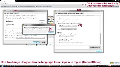
Yay! It was my first time to install Google Chrome on my pc. I've had a hard time figuring out how to change the default language settings which is in Filipino to English (US). The translation was a bit awkward though it's grammatically correct. But you see some English (especially the technical terms) just can't have a "decent" Filipino language counterpart. The tab "Sa ilalim ng hood" was quite obvious to be "Under the hood", but it just gave me a serious laugh. That phrase doesn't make sense at all on standalone conversations. hahaha... Anyways I documented how I did it. Just for fun. It was still an achievement of the day for me .(^_^)
Free Road data extracted from Open Street Map made available by Cloudmade . philippines.ai.zip (28.7M) philippines.img.zip (8.3M) philippines.navit.bin.zip (12M) philippines.osm.administrative.bz2 (627K) philippines.osm.bz2 (29M) philippines.osm.coastline.bz2 (3.5M) philippines.osm.highway.bz2 (16.2M) philippines.poi.gpx.zip (521.7K) philippines.poi.tomtom.zip (334.6K) philippines.poly (2.3M) philippines.shapefiles.zip (20.5M) Abra Agusan Del Norte Agusan Del Sur Aklan Albay Antique Apayao Aurora Basilan ...


Comments
Post a Comment