Minimizing my lidar velodyne point cloud
I think I should be reminding myself how I did the timestamping of the point cloud data with that of the GPS.
Here are the seemingly easy steps.
Now for some sort of discretization, I performed some thresholding of my LIDAR to point values to the specified usable range, 5cm to 100m.
I am now left with approximately 20% of my original data. Seemed like it's gonna work this time.
The next problem is how to fit my data with the baseline data and overlay them in the same coordinate system in my mapping software?
I have tried creating a Matlab script that would read my csv files with coordinates in ECEF-XYZ coordinate system and convert it to latitude longitude again. All the matrices of converted coordinates are appended in a single XYZ file for plotting later.
Here's the matlab script that I've created
Now I will just try to sort my data and remove some redundant ones. So what's next? Tomorrow, I'll have to try the fitting of the DEM(digiral elevation models). My next task is how to convert my topo maps in Autocad dwg format to contours to create a DEM. I think this is pretty much easier. I think, I hope...Let's see.(^_^)
Here are the seemingly easy steps.
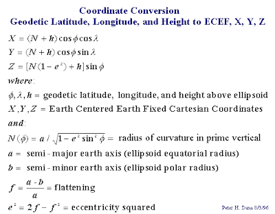
- I converted the GPS data from geographic lat, long, ht to an ECEF(Earth-centered-earth-fixed) cartesian coordinate system using this formula: The reason for conversion into cartesian is so that I can easily do the translation from our velodyne device to the GPS antenna. I used the WGS84 reference ellipsoid parameters for conversion. a = 6,378,137 m , 1/f= 6,356,752.3142
- Now after I got all my coordinates in X, Y, Z, I matched the timestamps in the LIDAR packets as that of the timestamp provided by the GPS.
- I then performed some translation based on the structure of the vehicle mount that we have fabricated for the fieldwork.
- Now my data is in X,Y,Z and ready for plotting in a point cloud software.

Now for some sort of discretization, I performed some thresholding of my LIDAR to point values to the specified usable range, 5cm to 100m.
I am now left with approximately 20% of my original data. Seemed like it's gonna work this time.
The next problem is how to fit my data with the baseline data and overlay them in the same coordinate system in my mapping software?
I have tried creating a Matlab script that would read my csv files with coordinates in ECEF-XYZ coordinate system and convert it to latitude longitude again. All the matrices of converted coordinates are appended in a single XYZ file for plotting later.
Here's the matlab script that I've created
for k = 1:5That's it, I never thought that could've been so simple. Thanks to the predefined classes and functions in Matlab. I think, I would be using it more often.:)
matFilename = sprintf('%d.csv', k);
M = ecef2lla(textread(matFilename));
dlmwrite('sample.xyz',M, '-append');
end
Now I will just try to sort my data and remove some redundant ones. So what's next? Tomorrow, I'll have to try the fitting of the DEM(digiral elevation models). My next task is how to convert my topo maps in Autocad dwg format to contours to create a DEM. I think this is pretty much easier. I think, I hope...Let's see.(^_^)


Comments
Post a Comment