Posts

Showing posts from November, 2010

Free online color matching tool for your maps

Image
 Maps do convey relevant information to a target audience.  Maps, apart from being informative, should be artistic too. Cartography is art. I mean you cannot just combine your violets with the greens or blues with it. A right combination of RGB or CMYK swatches will make it appear more pleasing and more eye-catching. And if you have 12 classes in a thematic map, you wouldn't want it to be randomly picked as if making some sort of lantern decoration for the Christmas season. Color coordination really is the name of the game. My husband who's into creative design is my one true critic when it comes to color combination. He would just peek into my final map for a project or laboratory exercise and then tell me to use this color or another color theme instead of my initial picks. He was such a relief when I am finishing my maps when he's at home. But when  he's not around, hard part comes. Anyways, I have stumbled upon this book last semester and found it really useful

Free PDF to WORD options

Image
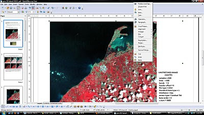
Latest versions of Microsoft Office and OpenOffice are already capable of  saving your  documents from doc, docx or odt to  pdf format. The reverse is quite unusual. There are trial versions of pdf to word converter with their limitations of course. PDF2Word  can only be used 100 times and allows the first 5 pages only to be converted to .doc format. Fonts change and the layout was a bit different after conversion.  The most useful for me is using the OpenOffice PDF Import Extension . If you have OpenOffice  installed in your pc, just double click the downloaded extension and an installation dialog will guide you through.  The pdf opens in OpenOfficeDraw and lets you do basic editing of text and images in the document. You can save the edited file as another pdf or export as an image file or in html format.  It's free and it's open source so let's see more developments of this extension on OpenOffice. It would be nicer if pdf files can be opened in OpenOffice.org Write

Free Class Schedule Notification on your Mobile Phone using Google Calendar

Image
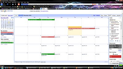
At long last, after one long week, I am finally enrolled for the 2nd sem AY 2010-2011. The entire enrollment experience has been really tedious and cumbersome because of usual queues, considering the enrollment is already online and automated. Anyways, I am now officially enrolled, so I would just have to tidy things up in my calendar. I set-up my Google Calendar to send me notifications of my scheduled class for the night on my mobile phone. The notifications are free so why not!It pays to be organized for some time anyways. Here's my schedule for this sem. And some other events/notifications on my Google Calendar. I created a test event for today and scheduled it to arrive 10 minutes before the time. Voila! I received a text message from Google saying: Reminder:test @ Thu Nov 11 12:20pm-1:50pm in PIVS (melanie's google calendar). Memorizing class schedule and room assignments have been quite a mess during my undergrad years. I used to print it and paste it on my not

Image Registration and Georeferencing in ENVI (Cavite, Philippines)

Image
Georeferencing and Registration Methodology T he following steps were undertaken for the rectification or georeferencing of the image: 1. I have created a subset of the province of Cavite from the Landsat ETM+image that I have downloaded from GLCF . A topographic map of the equivalent subset has been obtained with the following basemap information. Fig. 1: Basemap information Scale 1: 50000.. Sheet name Cavite, Philippines Sheet number 3163 II Source NAMRIA 2.  A scanned 1:50000 topographic map of Cavite appears below. Fig. 2a: 1:50000 Topographic map of Cavite 3.  An Image-to-map registration was performed using the coordinates on the boundary of the map as ground control points. A total of 10 points are obtained with a total RMSE of 0.396853. 4.  An Image-to-Image registration was later performed, yielding 9 GCPs with a total RMS error of 0.970929. The Landsat ETM+ image that I have obtained has alread

How to change Google Chrome language from Tagalog to English

Image
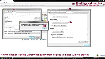
Yay! It was my first time to install Google Chrome on my pc. I've had a hard time figuring out  how to change the default language settings which is in Filipino to English (US). The translation was a bit awkward though it's grammatically correct. But you see some English (especially the technical terms) just can't have a "decent" Filipino language counterpart. The tab "Sa ilalim ng hood" was quite obvious to be "Under the hood", but it just gave me a serious laugh. That phrase doesn't make sense at all on standalone conversations. hahaha... Anyways I documented how I did it. Just for fun. It was still an achievement of the day for me .(^_^)

Principal Components Analysis

Image
 Principal Component Analysis (PCA) aims to eliminate the interband correlation and the effective dimensionality of the data or image. The false color composite of the original Laguna.img file appears below. Fig. 1: Standard color infrared composite image   The satellite image from Google Earth of Los Banos, Laguna was also included for identification of features and their names. Fig. 1a shows the saved image. Fig.1a: Google Earth image of Los Banos, Laguna   After subjecting the original image to principal components analysis, a color composite using PC1,PC2,PC3 as R,G,B respectively was produced. The color composite image was shown in the figure that follows. Fig. 2: RGB = PC1,PC2,PC3 of Laguna.img The six principal component grayscale images appear below. Fig. 3: Output principal component images  The tonal patterns of the principal component image 1 differ with that of ETM+ band 1 of Laguna.img. Figure 4 shows the a generlized view of the said differences on t